This research project provides an important contribution to the understanding of floodplain-scale surface water-groundwater interactions and the long-term hydrologic effects of these interactions on the hydrology of the northern portion of the Espanola Basin.
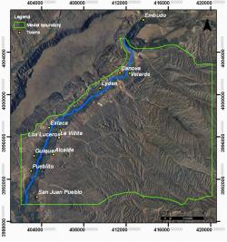
The project includes the development of a 3-D hydrologic model supported by a geological model of the study area (Fig. 1), which extends through the irrigated cropland corridor and its vicinity along the Rio Grande in the northern portion of the Espanola Basin. The study area is located about 3.5 miles northwest of Espanola, NM.